
Satellite Bushfire
Intelligence
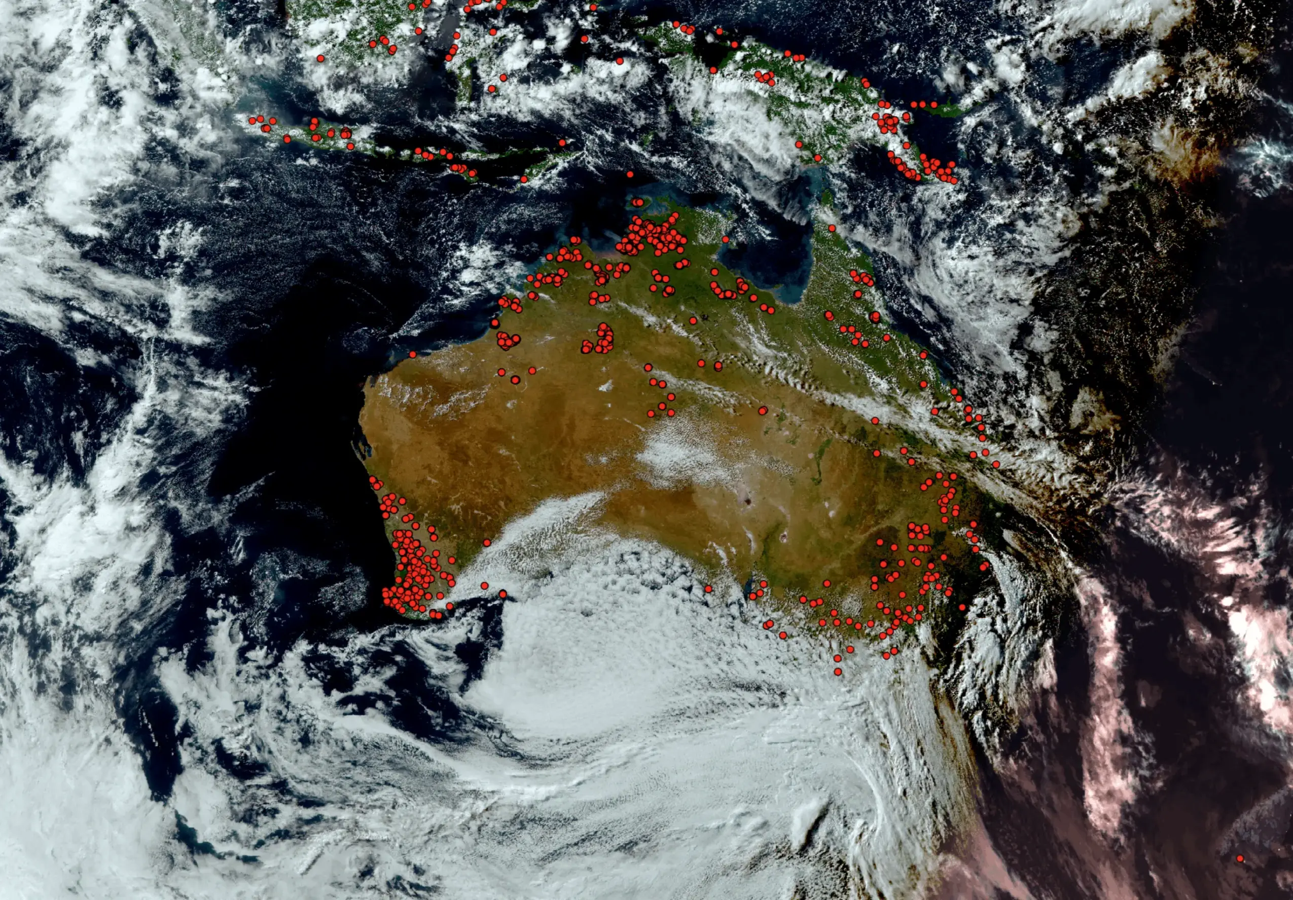
Near-real-time satellite hotspot detection, lightning tracking, and burnt area mapping for land managers, fire agencies, and researchers; covering Australia.
What is
?
is Australia's premier professional bushfire information system, developed and operated by Landgate, the Western Australian Land Information Authority, through its Earth Observation (Earth Observation) branch. It is the second-generation evolution of the original FireWatch programme, in continuous operation since the late 1990s.
The platform uses multiple orbiting satellites to detect and display fire hotspots, lightning strikes, vegetation greenness, burnt areas, and related environmental indicators across the whole of Australia. A national first in 2015 saw Landgate's Earth Observation team fine-tune satellite data to detect fires as small as 375 metres, effectively halving the previous minimum detectable fire size of approximately one kilometre.
firewatch-pro.landgate.wa.gov.au →
Why Satellite Fire Intelligence
Matters in Western Australia
Western Australia is one of the most bushfire-prone regions on Earth. Vast remote areas, the Kimberley, Pilbara, Midwest-Gascoyne, and Goldfields, stretch across millions of hectares where ground-based observation is impractical.
Vast Remote Areas
Before satellite systems, fire managers in remote regions had extremely limited situational awareness. Fires could burn enormous tracts of land before any human observer was within range, aerial patrols and ground surveys were the only options.
Lightning Ignitions
In remote WA, lightning-caused ignitions can smoulder for days before spreading into major fire events. Without 10-minute lightning position data, fire agencies have no early warning of likely ignition points before ground confirmation is possible.
Scale of Observation
Properties in northern WA can span tens of thousands of hectares. Consistent, regular satellite coverage of the entire continent provides the only practical means of monitoring fire activity across the full extent of managed land.
Built for Fire
Professionals
Fire Hotspot Detection
Satellite-derived active fire hotspots updated every 2–4 hours across all of Australia, detecting fires as small as 375 metres.
Lightning Detection
Lightning strike data updated every 10 minutes, showing precise locations of recent electrical activity to predict likely fire ignition points in remote areas before ground confirmation.
Burnt Area Mapping
Cumulative year-to-date burnt area records giving land managers a running spatial history of fire across the landscape, month by month, colour-coded.
Vegetation Greenness (MGW)
Near-real-time weekly greenness index derived from satellite imagery. Greener vegetation is less flammable; cured grass and dry scrub signals elevated fire risk across large landscapes.
Forecast Wind Overlay
Animated forecast wind direction and speed sourced from the Australian Bureau of Meteorology, allowing users to assess potential fire spread direction in real time.
High-Resolution Satellite Imagery
Frequent satellite imagery updates with finer spatial detail than the public-facing MyFireWatch platform, suitable for professional fire assessment and planning.
FireWatch Aurora Integration
Integration with FireWatch Aurora, the state-of-the-art fire spread prediction platform developed with DFES and the University of Western Australia, available to authorised emergency management personnel.
Free Registered Access + MFA
Full feature access is free to any registered user. Accounts are secured with multi-factor authentication, reflecting the platform's operational use by emergency services.

- —Hotspot refresh: every 2–4 hours (not real-time)
- —Smoke and cloud cover can obscure satellite views
- —Low-intensity prescribed burns under canopy may not trigger detection
- —Location accuracy ±2 km; up to ±5 km at image edges
- —Not a substitute for DFES live info see Emergency WA
How the Satellite
Detection Works
is built on more than 25 years of operational satellite data processing by Landgate's Earth Observation team, using US-operated satellites tuned to detect heat anomalies at sub-400-metre resolution.
Satellite Acquisition
Multiple satellites make continuous daylight passes over Australia. Their infrared sensors detect heat anomalies at the surface, including fire signatures.
Landgate Algorithm Processing
Landgate's Earth Observation team runs continuous pipelines that process raw satellite imagery, apply custom-tuned fire detection algorithms, and extract hotspot signatures, achieving 375m detection that was a national first in 2015.
Map-Based Delivery
Processed results publish directly to the web platform every 2–4 hours, combined with lightning data (10-minute cycle), BoM wind forecasts, and vegetation greenness for a complete operational picture.
Supporting Western Australia's
Fire Management Community
FireWatch Pro is explicitly positioned for professional use, with a guest access tier extending core functionality to anyone in Australia. It is used across emergency services, land management, research, and the pastoral sector.
Emergency Services
DFES and Volunteer Fire Brigades use FireWatch Pro and the FireWatch Aurora platform for operational fire management, resource dispatch, and situational awareness across WA.
Remote Land Managers
Pastoralists and station operators across the Kimberley, Pilbara, Midwest-Gascoyne and Goldfields use the platform to monitor fire on properties spanning tens of thousands of hectares.
Fire Behaviour Scientists
Researchers at institutions including the University of Western Australia use more than 25 years of validated hotspot, burnt area, and vegetation condition records for fire ecology and risk studies.
General Public
Guest access extends basic fire situational awareness to anyone in Australia, travellers in remote areas, communities in bushfire-prone regions, and those seeking to understand current fire conditions.
The Landgate Earth Observation Suite
FireWatch Pro
Professional-grade satellite fire intelligence for land managers, fire agencies, and researchers. Guest or free registered account.
MyFireWatch
Public-facing bushfire awareness tool developed with Edith Cowan University. Designed for general public use, particularly people in northern WA. Open, no login required.
FireWatch Aurora
State-of-the-art fire spread prediction and simulation tool built with DFES and the University of Western Australia. Restricted to authorised State Government emergency management personnel.
Floodmap
Professional-grade satellite flood intelligence for land managers, fire agencies, and researchers. Guest or free registered account.
Ready to Access
Professional Fire Intelligence?
Register for a free account to unlock the full feature set, or access core data as a guest with no login required.